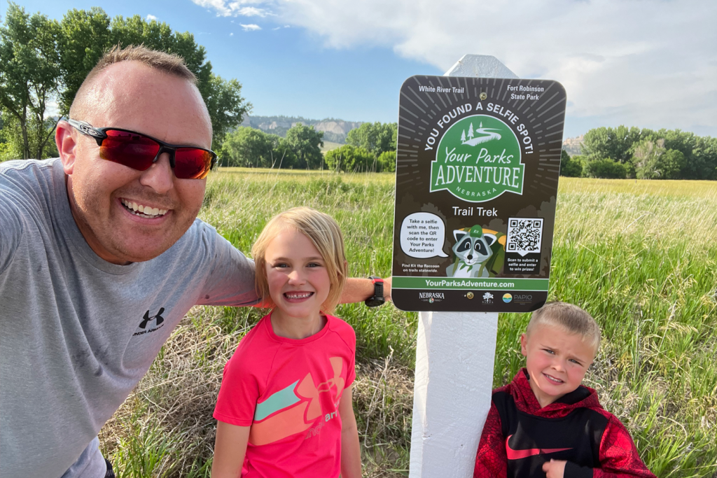
Your Parks Adventure
Explore trails. Find Kit. Win prizes!
2025 Trail Trek
Looking for a fun outdoor challenge? Embark on Your Parks Adventure from May 17-Oct. 31, 2025, for a chance to explore the state and be eligible for prizes! The 2025 Trail Trek features more than 50 designated trail locations across Nebraska. Your job: Find and take a photo with as many Your Parks Adventure signs featuring mascot Kit the Raccoon that you can.
How it works
Visit one of more than 50 designated trail locations during the 2025 contest. Once you find the Trail Trek sign, snap a selfie with Kit, scan the QR code and submit your picture to our online entry form.
The more trails you visit, the more chances you have to win. Participate on your own or with a group. Once you’ve entered your first trail submission, you will be entered for a chance to win prizes generously provided by our sponsors, including outdoor gear, Nebraskaland Magazine subscription, a two-night cabin stay and much more!
Trail locations
Kit the Raccoon can be found at each of these trail locations, typically within a mile of the trailheads. Trails included in the program are located at Nebraska Game and Parks areas, as well as participating city, county, federal, and Natural Resource District areas.
Explore the map for locations near you. The icons on the map indicate suggested starting points near parking lots for locating selfie signs; they do not indicate exact latitude and longitude. Find additional details about each trail location in the drop-down section.
The following is a list of communities nearest to our Trail Trek sign locations. Click on each community to find directions to Kit the Raccoon’s selfie signs!
Harlan County Reservoir
Trail: Pheasant Ridge Trail
Directions: The trailhead is west of gravel parking lot nearby. The second middle trailhead is located a sixth of a mile east from a dirt parking area off of Cornhusker Rd. From these two spots, head east or south respectively to find a three-way junction. This is where the sign will be posted. The sign is a mile in from the first trail head and a sixth of a mile from the second trailhead.
Total trail length: 3 miles
Surface type: paved sidewalk
Accessibility status: ADA accessible
Amenities: benches and trash receptacles
Entrance fee: free entry
Victoria Springs SRA
Trail: Victoria Creek Trail
Directions (two options): From the day use boat ramp parking area, the trailhead is located 30 yards north across from the playground. Follow the trail west until you reach the sign.
From the Victoria Springs campground trailhead located next to campsite 14, follow the paved trail until you reach the roadway next to the playground. Veer to your right (north) and reconnect with the day-use trailhead 50 yards from the paved trail. The sign is located a quarter of a mile from the campground trailhead.
Total trail length: 1.5 miles
Surface type: .09 miles is paved concrete and boardwalk, remaining trail is a dirt and grass covered trail
Accessibility status: partial (paved area is accessible)
Amenities: benches, playground, water hydrant, pet waste bag dispensers
Entrance fee: 2025 Nebraska state park vehicle permit
Eugene T. Mahoney State Park
Trail: Centurylink Lake Loop
Directions: The trail head is located to the Centurylink Lake parking lot. Centurylink Lake is located on the main park loop just south of Peter Kiewitt Lodge. The parking lot for the lake and trail head is located on the most southern face of the lake. You can access the trail via stairs or a switchback sidewalk located near the boat ramp. The trail is a full loop. If you head left (north), the sign will be approx. 800 ft. from the trailhead. If you head right (south), the sign will be approx. 2,300ft from the trailhead.
Total trail length: .56 mile
Surface type: dirt and rock path
Accessibility status: not ADA accessible
Amenities: Located near the trail are trash receptacles, benches and restrooms. As you go around the loop you will also have access to two fishing piers that allow you to overlook the lake.
Entrance fee: 2025 Nebraska state park vehicle permit
Rotary Island
Trail: Optimist Lake Trail
Directions: The sign is located immediately east of the parking area, just south of the Nemaha County Saddle Club arena.
Total trail length: The total perimeter of the trail is approximately .5 miles with additional interior loops.
Surface type: paved sidewalk
Accessibility status: ADA accessible
Amenities: There are restrooms, trash receptacles, benches, picnic tables and a picnic shelter.
Entrance fee: free entry
Chimney Rock National Historic Site
Trail: Trail A (north side)
Directions: From the trailhead parking lot and patio, there are two ways to enter Trail A, as it is a large loop. Taking either path will lead to the sign.
Total trail length: ~1 mile
Surface type: crushed rock
Accessibility status: ADA accessible
Amenities: At the parking lot is a large patio with two benches with cover. One portable toilet is available at the parking lot from May to October.
Entrance fee: free entry
Papio Missouri NRD – Prairie View Recreation Area
Trail: Prairie View Lake Trail
Directions: Since the trail is a loop, you can go either direction of the trail. Both trails start at the parking area, with the shorter route (counter clock wise) heading west past the gazebo.
Total trail length: 1.5 miles
Surface type: crushed limestone
Accessibility status: ADA accessible
Amenities: primitive restrooms, gazebo, boat ramp, and jetties for shore fishing. No trash receptacles, so pack your trash out.
Entrance fee: free entry
Nemaha NRD
Trail: Steamboat Trace Trail
Directions: The Steamboat Trace Trail Access is located one block east of Brownville Welcome Center from Highway 136 and E. Main St. Brownville, NE. Turn left on Steamboat Trace Trail and head North, which goes under the Highway 136 Missouri River bridge, approximately 2,000 feet. Trail Trek Sign is on right side of Scenic Missouri River wood rail fence.
Total trail length: ~22 miles
Surface type: crushed limestone
Accessibility status: At this time trail surface is ADA compliant, but trail access is not.
Amenities: All amenities are located in Village of Brownville, NE. This included coffee/ice cream shop, restaurant, bar, museums, Historic buildings, public restrooms, art shops, Brownville Village Theater, and Whiskey Run Creek Winery and Distillery. All amenities are within six blocks of Brownville Welcome Center and Steamboat Trace Trail.
Entrance fee: free entry
Central Park
Trail: Dark Island Trail
Directions: The trailhead is on M Rd in Central City. It is just east of the Central City high school. There is ample parking and a trailhead sign with a map. The sign is approximately half a mile north on the trail.
Total trail length: 8 miles
Surface type: crushed rock
Accessibility status: not ADA accessible
Amenities: restrooms, water and playground (located at Central Park); benches along the trail, trash receptacles
Entrance fee: free entry
Chadron State Park
Trail: Norwesca Trail
Directions: Take the road to the Blackhills Overlook Trail and park in the mowed field to the north by the Norwesca Trail and Steamboat Butte Trail sign. The trailhead is to the south of the parking lot and has a sign “Pine Ridge Trail” with an arrow. Take this trail it is the start of Norwesca Trail. Follow this trail for 350 yards and the sign will be on the left overlooking the Pine Ridge forest.
Total trail length: 1.6 miles
Surface type: dirt path
Accessibility status: not ADA accessible
Amenities: The trail is located on the south edge of the park and there are no amenities nearby.
Entrance fee: 2025 Nebraska state park vehicle permit
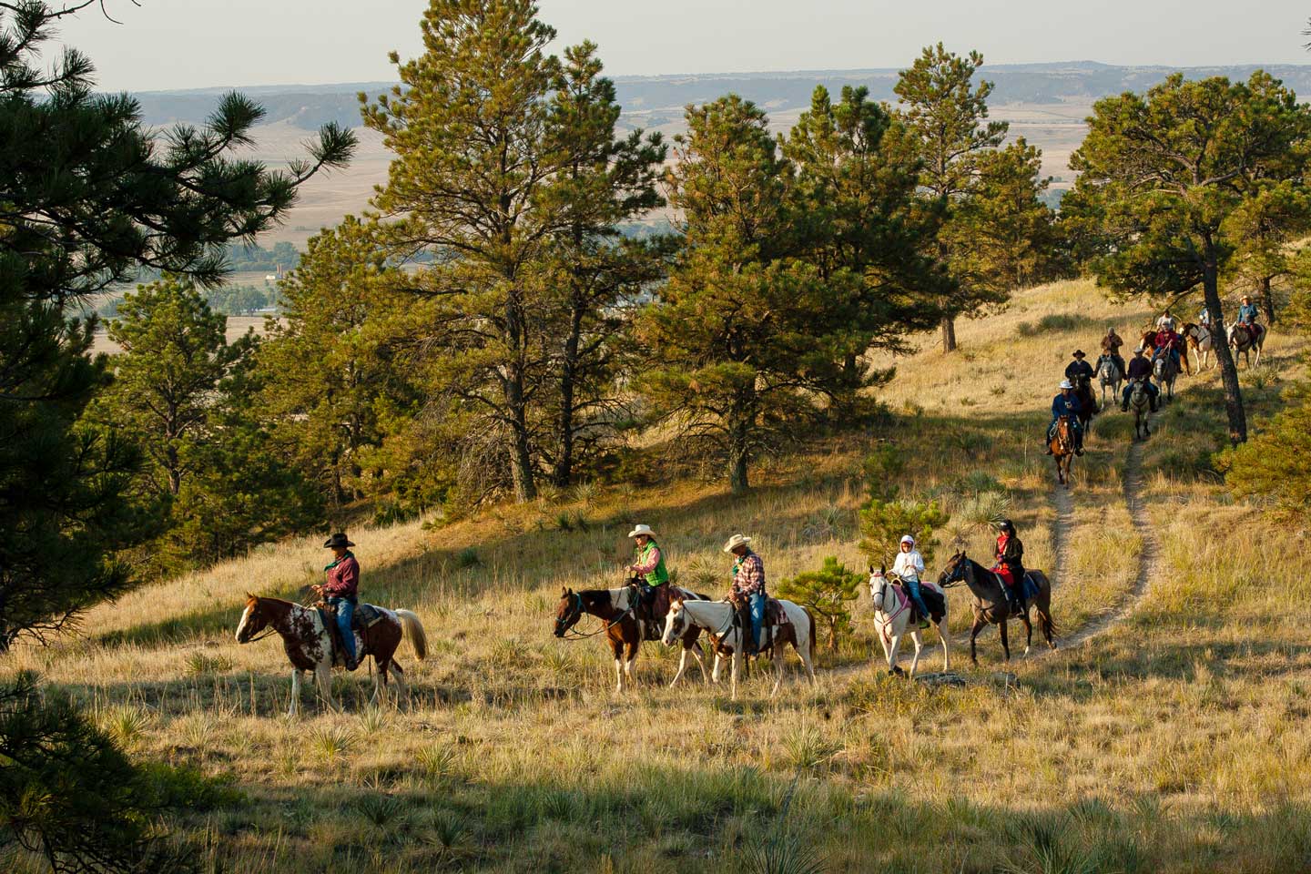
Fort Robinson State Park
Trail: White River Trail
Directions: The trailhead is located on the east end of the Fort Robinson State Park building complex. Once in the park, turn east off of highway 20 by the Post Playhouse. The trail head is on the left-hand side of the road where the blacktop meets the gravel road.
Total trail length: 2.5 miles
Surface type: crushed rock
Accessibility status: not ADA accessible
Amenities: Two shelters with benches are located on the trail. Restrooms, water hydrants/fountains, playground and trash receptacles are within 1/4 mile of the trailhead.
Entrance fee: 2025 Nebraska state park vehicle permit
Lewis and Clark SRA
Trail: South Shore Trail
Directions: Start at the South Shore trailhead (see the map below) and stay on it until there is a intersection, then take a left onto Cedar Ridge Trail. From there, the sign is about 100 yards up the hill.
Total trail length: 4.5 miles
Surface type: dirt path and mowed grass
Accessibility status: not ADA accessible
Amenities: benches, vault toilets, water hydrant and trash receptacles
Entrance fee: 2025 Nebraska state park vehicle permit
Mormon Island SRA
Trail: Chain-of-Lakes Trail
Directions: Park at the “Chain-Of-Lakes” trailhead parking area near Bullhead Pond, northeast of the swimming beach area. Enter the trailhead to the north, working east around the trail path along north side of Bullhead Pond until you come to a meadow.
Total trail length: 1 mile
Surface type: mowed grass and dirt path
Accessibility status: not ADA accessible
Amenities: restrooms, campgrounds, trash receptacles, playground, pond for fishing, water hydrant near campsite #18
Entrance fee: 2025 Nebraska state park vehicle permit
Enders Reservoir SRA
Trail: Lookout Point Trail
Directions: The trailhead is located on the north side of Enders Dam. West side of the highway 6 and across from the Enders Park headquarters. There is a wooden sign (says Lookout point )on the road going up to the trail. Once up on top will see the trailhead sign.
Total trail length: ~3 miles
Surface type: dirt path
Accessibility status: not ADA accessible
Amenities: Restrooms, picnic areas, trash receptacles and a playground are located near the trail.
Entrance fee: 2025 Nebraska state park vehicle permit
Rock Creek Station State Historical Park
Trail: Legacy Loop Trail
Starting point: The trailhead is west of the park office’s parking lot. Head west on the trail to where the wagon ruts come up the hill. Looking down the hill, you will see one of the West ranch cabins.
Total trail length: about 3/4 miles if taking the loop
Surface type: mowed grass
Accessibility status: not ADA accessible
Amenities: Full restroom facilities are located at the trailhead (inside of the Visitor Center), with vault toilets, picnic tables and benches located at the sign site near the Historic West Ranch.
Entrance fee: 2025 Nebraska state park vehicle permit
Fremont Lakes SRA
Trail: Lake #17 Trail
Directions: The Trailhead is east of West Victory Shower House. Head out on the trail and look for the sign.
Surface type: crushed rock trail
Accessibility status: not ADA accessible
Amenities: restrooms, trash receptacles, playground, fishing access
Entrance fee: 2025 Nebraska state park vehicle permit
Wildcat Hills SRA
Trail: Northlook Trail
Directions: The trailhead for the Northlook and Nature Trails is just North (behind) of the Nature Center. The first part of the trail doubles as part of the Nature Trail. Walk/hike North on the Nature Trail until you reach the Service Road. At that point continue North across the Service Road and you will see the sign for the North Look Trail. Continue North on the trail until you reach the fence at the Northern most overlook, where the trail ends. The Trail Trek sign will be right along the fence in front of you.
Total trail length: ~1.25 each way, 2.5 round trip
Surface type: dirt path
Accessibility status: not ADA accessible
Amenities: There are a few benches along the way. Water and Restrooms are in the Nature Center at the start of the Trail.
Entrance fee: 2025 Nebraska state park vehicle permit
Windmill SRA
Trail: Waupans Trail
Directions: Due to construction, the Trail Trek sign has been moved to the west end of Lake #1, near the trailhead access point.
Total trail length: ~50 yards from the trailhead
Surface type: mowed grass
Accessibility status: not ADA accessible
Amenities: bench, modern restrooms, trash receptacles
Entrance fee: 2025 Nebraska state park vehicle permit
Cowboy Recreation and Nature Trail
Trail: Cowboy Trail
Directions: Parking can be found at the Moore Field in Gordon. Head west on the Cowboy Trail for 3/4 of a mile. The sign is near the shelter and bench.
Total trail length: 317 miles
Surface type: crushed limestone
Accessibility status: not ADA accessible
Amenities: none
Entrance fee: free entry
Nebraska State Fair
Find Kit the Raccoon and submit your selfie during the Nebraska State Fair! Visit Nebraska Game and Parks in the Nebraska Building any time during the fair, Aug. 22 – Sept. 1.
Schramm Park SRA
Trail: Canyon Ponds and Interactive Stream
Starting point: The trail begins on the ADA ramp on the north side of Bluebird Road in front of the Hatchery Museum.
Total trail length: 300 feet
Surface type: cement and wooden boardwalk
Accessibility status: ADA accessible
Amenities: benches, restrooms, trash receptacles, water fountain, picnic tables
Entrance fee: 2025 Nebraska state park vehicle permit
Nebraska National Forest at Halsey
Trail: Scott Tower Overlook
Directions to trailhead: Turn off Highway 2 onto 86B. Avoid the curve and go straight into the Bessey Recreation Complex. Continue straight until you must turn left. There will be a parking lot to your left, a building to your right and the Camp Host site in front of you. Turn right at the next turn. Continue out of the campground. You will cross a cattle guard. The trailhead sign will be on your right.
Total trail length: ~3 miles to the tower (one way); 6 miles round trip
Surface type: wood chips
Accessibility status: not ADA accessible
Amenities: Restrooms, water and trash receptacles are located in the Bessey Recreation Complex.
Entrance fee: free entry
Lib’s Park to Lake Hastings Park
Trail: Pioneer Spirit Trail
Directions: To begin your adventure, park at the trail access area along South Shore Drive on the west side of Lake Hastings Park. Follow the trail to the northeast and then veer right over the footbridge. You’ll find Kit about 100 yards past the bridge near the dragonfly sculpture.
Total trail length: 10 miles of connected trails
Surface type: paved sidewalk
Accessibility status: ADA accessible
Amenities: benches, drinking fountain, restrooms, playgrounds, trash receptacles, picnic shelters
Entrance fee: free entry
Fort Kearny SRA
Trail: Hike & Bike Trail
Directions: Enter the Fort Kearny SRA from the south entrance, turn right and head north. The trail entrance is on the east side, just past East Campground.
Total trail length: 1.4 miles
Surface type: paved sidewalk
Accessibility status: ADA accessible
Amenities: pit toilet, trash receptacles and benches along the trail
Entrance fee: 2025 Nebraska state park vehicle permit
Ted Baldwin Park
Trail: Meadowlark Trail
Directions: Go north from gravel parking area, within Ted Baldwin Park, approximately 400 ft. Turn left and go west and follow the trail for about 1,500 ft. You can also access the sign by taking a more natural trail about 1,200 ft. west of the parking area.
Total trail length: 2 miles
Surface type: paved sidewalk
Accessibility status: ADA accessible
Amenities: Benches, restrooms, a water fountain, trash receptacles and a playground at all within walking distance of the trail.
Entrance fee: free entry
Ash Hollow State Historical Park
Trail: Overlook Trail
Directions: The trailhead begins in the parking area on the west side of Highway 26. Go straight from the trailhead. After 600 feet, take the trail to your right. There is a sharp incline, roughly 200 feet long, until you get on top of the hill. Then it flattens out into a loop.
Total trail length: ~3/4 mile
Surface type: mowed grass and dirt path
Accessibility status: not ADA accessible
Amenities: There are no amenities at this location, but the trail is across the highway from the Visitors Center which has trash receptacles, picnic tables, modern restrooms and a water fountain.
Entrance fee: 2025 Nebraska state park vehicle permit
City of Lincoln
Trail: Fletcher Landmark Trail
Directions: The nearest parking area is either residential street parking (on STREET) or the nearby apartment complex’s parking lot (lot is located on the north side Fletcher.) Sign is located southwest of the intersection of Fletcher Ave and Rockford Drive.
Total trail length: 1.2 miles
Surface type: paved sidewalk
Accessibility status: ADA accessible
Amenities: none
Entrance fee: free entry
Wilderness Park
Trail: Rock Island Trail
Directions: The trailhead is north of the parking lot at Densmore Ballfields. Start at the parking lot and walk about 175 feet northeast on the sidewalk, then turn left to go 475 feet northwest to get to the trailhead. From there, turn left again (southwest) until you cross the bridges over the railroad tracks, leave the paved trail and continue on the crushed rock trail in Wilderness Park and reach the sign near the bridge over Salt Creek. The walk from the trailhead is approximately 0.5 miles.
Total trail length: 6.71 miles
Surface type: paved sidewalk
Accessibility status: ADA accessible
Amenities: benches
Entrance fee: free entry
Mahoney Park
Trail: Murdock Trail
Directions: Along the north side of Mahoney Park, a short walking path is located to connect the Murdock Trail south to the Shanda Dixon, runs adjacent to Mahoney Drive road, to a new drinking fountain along the Shanda Dixon Trail.
Total trail length: 4.73 miles
Surface type: Crushed rock trail and some paved with a dirt path between the Murdock and Shanda Dixon Trails.
Accessibility status: Mostly, yes. There may be areas that are slightly more difficult to navigate with a mobility device.
Amenities: Mahoney Park is currently in the process of a playground renovation. The inclusive playground, which will be located just south of the Dixon/Murdock connecting walking path, will be completed this summer. Bathrooms are nearby, as are water fountains and trash receptacles.
Entrance fee: free entry
Cowboy Nature and Recreation Trail
Trail: Cowboy Trail
Directions: Parking can be found at the City Park on Main St. Head east on the Cowboy Trail for 1/10th of a mile.
Total trail length: 317 miles
Surface type: crushed limestone
Accessibility status: accessible when dry
Amenities: none
Entrance fee: free entry
Long Pine SRA
Trail: Creekside Journey Trail
Directions: From the parking area at the bottom of the hill after entering the park, walk down the crushed rock trail about 40 yards downhill, until you come upon the foot bridge crossing Pine Creek. The starting point of the trail is the bridge, and the trail follows the east side of the creek south hugging the side of the canyon under a canopy of trees.
Total trail length: half a mile
Surface type: crushed rock and dirt
Accessibility status: The trail after crossing the foot bridge is not ADA accessible, but the trail from the sign to the lower campground following the creek is crushed rock and flat allowing for the use of wheelchairs and other mobile devices.
Amenities: benches are located along the trail (pack out your trash)
Entrance fee: 2025 Nebraska state park vehicle permit
Platte River State Park
Trail: Ruthie’s Backyard Trail
Directions: The trailhead is at the east Mountain Bike parking lot. Follow the signage west down the double track trail. Head north at the Ruthie’s Backyard Trail sign. Follow the trail until you reach the scenic overlook known as Ruthie’s point.
Total trail length: ~1 mile, round trip
Surface type: dirt path
Accessibility status: not ADA accessible
Amenities: There is a picnic table and pit toilet at the east mountain biking lot. There is also a bench at Ruthies Point where the trail trek sign will be stationed.
Entrance fee: 2025 Nebraska state park vehicle permit
Pawnee SRA
Trail: Trail to Area 1
Directions: Take the entrance road south into Lakeview Campground. There will be a parking lot on the left side of the road on the way to the campground near the trailhead.
Total trail length: 1.5 miles
Surface type: dirt path
Accessibility status: not ADA accessible
Amenities: parking lot; no other amenities at this site
Entrance fee: 2025 Nebraska state park vehicle permit
Mulberry Bend Overlook
Trail: Mulberry Bend Overlook Trail
Directions: From the parking area, a short, paved trail leads to two overlooks that offer views of a free-flowing segment of the Missouri River.
A moderately strenuous unpaved trail begins at the upper viewpoint at the end of the paved trail. It is a 3/4 mile trail consisting of a loop with 2 spurs to viewpoints overlooking the river. The route winds through dense bluff forest of bur oak, cedar, ash, and other native trees.
Total trail length: 1 mile
Surface type: paved sidewalk, stairs, and a dirt path
Accessibility status: For the first two overlooks, the trail is paved, intended to be gradually sloping with a break, and has a turnaround width wide enough to accommodate a wheelchair.
Amenities: A picnic table, shade shelter, and vault toilet are available near the parking lot. Viewfinders are available at the first overlook.
Entrance fee: free entry
Red Willow Reservoir SRA
Trail: Buffalo Roam Trail
Directions: The trail is off to your left as you turn into the parking lot of Buffalo Roam Campground. You can see the sign from the parking lot.
Total trail length: 1.2 miles
Surface type: dirt path
Accessibility status: not ADA accessible
Amenities: shelters, restrooms, water hydrant, trash receptacles and playground nearby
Entrance fee: 2025 Nebraska state park vehicle permit
Lewis and Clark Visitor Center
Trail: DeBruce River Overlook Trail
Directions: The trailhead is about 2 blocks northeast of the parking lot. Look for the sign located next to the patio behind the Center’s main building.
Total trail length: The main path is 500 yards long. There are two offshoots: the Birding Trail is 300 yards long and the Limestone Trail is 1000 yards long.
Surface type: wood chips
Accessibility status: not ADA accessible
Amenities: There is a gazebo with benches and trash receptacles overlooking the Missouri River. There are several benches along the Limestone Trail. The Limestone Trail leads to the Native American Earthlodge.
Entrance fee: free entry
Cowboy Recreation and Nature Trail
Trail: Cowboy Trail
Directions: Parking can be found at the Neligh Mill. Head north to the Cowboy Trail and head west for 1/2 a mile. The sign is near the intersection of HWY 14 and Cowboy Trail.
Total trail length: 317 miles
Surface type: crushed limestone
Accessibility status: accessible when dry
Amenities: There are no amenities at this site.
Entrance fee: free entry
Niobrara State Park
Trail: 3 mile loop (road)
Directions: The sign is located near the second parking area on the south side of the 3 mile loop near the picnic shelter at the highest point in the park.
Total trail length:
Surface type:
Accessibility status: not ADA accessible
Amenities:
Entrance fee: 2025 Nebraska state park vehicle permit
Buffalo Bill SRA
Trail: Scout Trail
Directions: The trailhead is located on the south side of the beach near the backwater of the North Platte River. There is a parking lot across the street from the beach and trail. The sign is located at the head of the trail where the river meets the backwater behind RV camping site 23.
Total trail length: 3 miles
Surface type: dirt, silt, grass and sand
Accessibility status: not ADA accessible
Amenities: restrooms, benches and trash receptacles
Entrance fee: 2025 Nebraska state park vehicle permit
Iron Horse Park
Trail: Iron Horse Trail
Directions: Enter the trailhead on the north end of the parking lot on the west side of the park. Follow trail around the north side of the lake until you reach the sign on right side of trail.
Total trail length: 2,500 feet
Surface type: paved sidewalk
Accessibility status: ADA accessible
Amenities: restrooms (south side), playground, trash receptacles, concrete boat ramp
Entrance fee: free entry
Lake Ogallala SRA
Trail: Lake Ogallala Hike & Bike Trail
Starting point: The trailhead located on the south side of the Lake Ogallala’s east campground.
Total trail length: 1.8 miles to Diversion Dam and 1.8 miles back to the trailhead
Surface type: mix of rock and dirt
Accessibility status: This trail is not ADA accessible. However, a wheel chair or stroller can be pushed on trail or accessed by power assist chairs.
Amenities: Restrooms, shower, drinking fountain and trash receptacles are located 100 yards from the trailhead. Benches are located near start and end of trail. A dog waste station is located at trailhead.
Entrance fee: 2025 Nebraska state park vehicle permit
Adams Park
Trail: Adams Park Trail
Directions (two options): The main access for the trail is from the Adams Park Community Center Parking lot located at 3230 John Creighton Boulevard. Going west on the trail from the parking lot about 100 yards look for the sign.
Another small parking lot for trail access is located Near Malcom X Avenue and Bedford Avenue. The sign is located where the parking lot sidewalk connects to the trail.
Total trail length: 1.2 miles
Surface type: paved sidewalk
Accessibility status: ADA accessible
Amenities: benches, playgrounds, restrooms, trash receptacles
Entrance fee: free entry
Chalco Hills Recreation Area
Trail: Wehrspann Lake Trail
Directions: The trailhead can be found to the north of the parking area. Take the trail north for close to a half mile until you reach a clearing with a view of the lake(You should see the boat ramp and parking directly west on the other side of the lake).
Total trail length: north loop – 4.5 miles; full loop – 7.2 miles
Surface type: paved sidewalk
Accessibility status: ADA accessible
Amenities: benches, primitive restrooms, trash receptacles
Entrance fee: free entry
Cowboy Nature and Recreation Trail
Trail: Cowboy Trail
Directions: Parking can be found at the Dry Creek WMA parking lot. Head east for .3 miles, the sign is near the bridge over the Elkhorn River.
Total trail length: 317 miles
Surface type: crushed limestone
Accessibility status: accessible when dry
Amenities: there are no amenities at this location
Entrance fee: free entry
Davis Creek Recreation Area
Trail: Davis Creek Recreational Area Trail
Directions: Turn south off Highway 22 near North Loup, Nebraska onto Ashton Avenue, continue 5.45 miles south on Ashton Ave, turn left (east)on unmarked road for 1/2 mile. Find the trailhead on the north side of the road just past campsite #1 in the RV campground. The sign is located near the trailhead.
Total trail length: 5+
Surface type: dirt
Accessibility status: not ADA accessible
Amenities: restrooms, picnic tables, potable water, shower house, playground, trash receptacles, playgrounds, picnic shelters
Entrance fee: free entry
Big Elk Recreation Area
Trail: Big Elk Loop Trail
Directions: From the parking lot, take the trail south.
Total trail length: 1 mile loop
Surface type: paved sidewalk
Accessibility status: ADA accessible
Amenities: boat ramp, picnic shelter and tables, restrooms
Entrance fee: free entry
Willow Creek SRA
Trail: William J. Meyer Memorial Trail
Directions: Park in the paved lot at the southwest end of the main portion of the park with paved roads. The sign is located at the trailhead on the west end of the parking lot.
Total trail length: 10 miles
Surface type: crushed limestone
Accessibility status: ADA accessible
Amenities: benches, restrooms at trailheads, trash receptacles, playground.
Entrance fee: 2025 Nebraska state park vehicle permit
Ponca State Park
Trail: Corps of Discovery Trail
Directions: The trailhead is between the boat ramp and Riverfront campground. There is a staircase to lead you on the trail.
Total trail length: 1.5 miles
Surface type: dirt path
Accessibility status: not ADA accessible
Amenities: playground, trash receptacles, pit toilet, campgrounds, benches, water hydrants
Entrance fee: 2025 Nebraska state park vehicle permit
Branched Oak SRA
Trail: Area #14 Trail
Directions: Park in the small parking lot 1/8th of a mile west of the intersection of West Raymond Road and Crounse Road, just off West Raymond Road. From the parking area, head west and then take the east path until you reach the sign.
Total trail length: ~1 mile; there is an option at the half mile to connect to a larger portion of the trail that runs for four to five miles.
Surface type: wide dirt path
Accessibility status: Not ADA accessible, but individuals in wheelchairs have accessed this path.
Amenities: There is no drinking water, shelters, or toilet facilities in the parking area. The trail passes by Area #14 where there is a pit toilet.
Entrance fee: 2025 Nebraska state park vehicle permit
Cowboy Nature and Recreation Trail
Trail: Cowboy Trail
Directions: Parking can be found at on Main St, near the Cowboy Trail. Head east on the Cowboy Trail and for 1 mile. The sign is near the short trail bridge.
Total trail length: 317 miles
Surface type: crushed limestone
Accessibility status: not ADA accessible
Amenities: none
Entrance fee: free entry
Terry Carpenter Park
Trail: Monument Valley Pathway
Directions: The trailhead is located by the north parking area between the 23 Club fields and Terry Carpenter Park. Go left at the shelter toward the pedestrian bridge.
Total trail length: 7.1 miles
Surface type: paved concrete
Accessibility status: ADA accessible
Amenities: Restrooms available northeast corner of Frank Park, just 400 yards south of the trailhead. Terry Carpenter Park has a picnic shelter with tables and benches, trash cans and dog park. A playground is located in Frank Park just south of the trailhead.
Entrance fee: free entry
Sherman Reservoir SRA
Trail: Lakeview Trail
Directions: The parking is located on the southeast end of the dam road. From the parking area walk north to find the trailhead about 50 yards and slightly off to the left.
Total trail length: 1.5 miles
Surface type: mowed path
Accessibility status: not ADA accessible
Amenities: none at the trailhead; see park map for amenities
Entrance fee: 2025 Nebraska state park vehicle permit
Indian Cave State Park
Trail: Trail #9
Directions: The trailhead is located along the main road (approximately four miles from the park entrance) and across the road from the first parking area, just past the boat ramp road.
Total trail length: 1 mile
Surface type: dirt
Accessibility status: not ADA accessible
Amenities: pit toilet, trash receptacles, Indian Cave Bend Shallow Water Habitat Area
Entrance fee: 2025 Nebraska state park vehicle permit
Summit Lake SRA
Trail: Fishing Pier Trail
Directions: The trailhead is west of the south boat ramp. Follow the paved path to the wooden fishing pier.
Total trail length: 1,000 feet
Surface type: paved sidewalk
Accessibility status: ADA accessible
Amenities: Benches, restrooms, swimming beach, boat ramp, kayak launch, small shelter, playground
Entrance fee: 2025 Nebraska state park vehicle permit
Cowboy Nature and Recreation Trail
Trail: Cowboy Trail
Directions: Parking can be found at the Cowboy Trail Trailhead in Valentine. The sign is next to the most rural bike share station in the US.
Total trail length: 203 miles
Surface type: crushed limestone
Accessibility status: not ADA accessible
Amenities: benches along the trail (no restrooms at the trailhead)
Entrance fee: free entry
Fort Niobrara National Wildlife Refuge
Trail: Fort Falls Hiking Trail
Directions: When you enter the park you will find the Visitor Center at the top of the hill. Follow the signs that say Fort Falls. Take the road that passes in front of the Visitor Center. When you get to a T, take a short right and then a left. Follow the road and the signs. At the next intersection, keep left. You will come to a circle drive and parking area. There will be a viewing area and information – the the trail will begin here.
Total trail length: ~1 mile loop
Surface type: The trail is a mix of concrete, concrete steps, metal bridgeways and railings, metal stairs. It will turn to dirt at the bottom, and continue on a dirt trail as you loop along the river and up the canyon. Expect some uneven ground at times.
Accessibility status: The trail is not accessible, only the parking area.
The sign is located at the parking lot at the start of the trail.
Amenities: Restrooms, water, trash receptacles, benches and information are located at the Visitor Center.
Entrance fee: free entry
River Park
Trail: Dinklage Trail
Directions: If parking by the big baseball field and walking the trail along the river, the sign will be straight south of 3rd base of the big baseball field.
Total trail length: ~1.3 miles; if you include the Nielsen Trail, 1.7 miles
Surface type: paved concrete
Accessibility status: ADA accessible
Amenities: benches, restrooms, water fountains, trash receptacles, playground, picnic shelters, dog park, basketball court, kids fishing pond
Entrance fee: free entry
2024 Trail Trek
More than 850 individuals and families explored Nebraska’s trails last summer and fall as part of Your Parks Adventure: Trail Trek, a free program offered by the Nebraska Game and Parks Commission and the Nebraska Recreation and Parks Association.
The program, new in 2024, encouraged people to explore 48 designated trail sites across Nebraska, where they snapped selfies with a Trail Trek sign. Trails included Nebraska Game and Parks areas, as well as participating city, county, federal and Natural Resource District areas. From May to October, participants made over 5,100 visits to these trails.
The grand prize winners – Mary Dooley of Norfolk and Marge Gray of Omaha – will enjoy a two-night cabin stay at a Nebraska state park, a 2025 Nebraska park entry permit, an annual subscription to Nebraskaland Magazine, a backyard birding package and more.
- Anne Herman, Omaha: Biking package
- Cheryl Gerkins, Lincoln: Camp cooking package
- David Miller, Beaver Crossing: Fishing package
- Jessica McGinley, Valentine: Hiking package
- Ida Van Scyoc, Shenandoah, Iowa: Hiking package
- Barbara Schaefer, Pierce: Birding package
- Christina Valenzuela, Orleans: Camping games package
- Martin Versaw, Lincoln: Camping games package
- Richard Hanigan, Lincoln: Camping games package
Go Pro
- Rebecca Miller, Beaver Crossing
- John Grebl, Papillion
GPS
- Doug Hubbard, Omaha
- Deb Watchorn, Lincoln
$250 gift card
- Mary Mohler, Superior
- Tiffany Schank, Scottsbluff
- Maddie Coe, Crete
- Brigitte Schreck, Papillion
$100 gift card
- Rebecca Clark, Lincoln
- Betty Mann, Berwyn
- Karen Rueschhoff, Lincoln
- Deb Blank, Hadar
$50 gift card
- Tracy Vrba, Columbus
- Diane Hofer, Seward
- Charlotte Waters, Colorado Springs, CO
- Lori Landis, Waverly
Hiking stick
- Betty Lou Lang
- James Andrysik
- Kim Kanellis
- Rachel Miller
- Wendi Nelson
- Charlie Wood
- Linda Sparks
- Sheri Adams
2025 Annual Park Permit
- Dennis Zabel
- Melissa Canterberry
- Douglas Abele
- Melissa Kirkpatrick
- Karen Griffin Sieber
- Beth Singleton
- Rick Erdei
- Justin Broughton
- Crystal Schank
- Tammy Hubl
- Lora Sypal
- Anne Gibbs
- Gwen Mohler
- Kendra Sullivan
- Jim Frohman
- Tisha Thacker
- Joe Warner
- Randy Douglas
1-year Nebraskaland Magazine Subscription
- Daniel Schreck
- Lori Gothier
- Kate Stephens
- Susan Whited
- Valerie Beraun
- Becky McHenry
- Anastasia Davis
- Mathew Ellison
- Lynn McCollough
- Krista Deal
- Tyler Mainquist
- Jim Prokopec
- Sarah Jones
- Tammy Stuhr
- Catherine Nixon
- Kathy Trudell
- Christy Hofer
- Shawnee Armstrong
Nebraskaland Calendar
- Marie Wardyn
- Debbie Aden
- Denise Mainquist
- Karla Pineda Gutierrez
- Spencer Green
- Sheri Pfeil
- Paul Cox
- Michael Eberspacher
- Shaina McIntosh
- Krista Testin
- Paulette Kuhlman
- Robert Grebl
- Nicole Boon
- Steve Fosbender
- Sue Holliday
- Michelle Pretty
- Jericho Johnson
- Jerry Brittain